We backpacked the Timberline Trail for the first time in August 2020 and since completing the lap around the mountain I have found it frequently on my mind. Whenever I see Mt. Hood from Portland I think proudly, Hey I walked around that! We have not done much hiking since our family expanded from three to five, but over the last year and a half I have spent hours each week building my aerobic fitness and strength on our Peloton bike and by taking classes on their impressive platform of other content (strength, Pilates, stretching, yoga, meditation, etc.). And hey, pushing our three year old twins in a double stroller up the hills in our Southwest Portland neighborhood probably helps too.
The last time Lindsay and I backpacked together, it was August 2021 when we completed the Northern Loop in Mount Rainier National Park with my brother Myles and his now wife Hannah. Shortly after that trip, I became pregnant with our twins… and poof nearly four years passed before we had the opportunity to go backpacking together again. (Thanks Mimi and Pop Pop!)
Just a few weeks ago, I backpacked the High Lonesome Loop in the Indian Peaks Wilderness with my sister Kristin (I hope to write up a post about that trip soon) and overall I felt great, even with the high altitude - a lot of time spent hiking and sleeping between 10,000 and 11,000 feet. It was so special to have time on the trail with my sister, and feeling good and strong while hiking definitely boosted my confidence.
I knew completing the Timberline Trail in just two nights would be challenging and possibly too much. We had a contingency plan - to go out as far as we felt we could go and backtrack over the next two days if we just weren’t feeling it. But after tossing the idea out to Lindsay I found myself consumed by the prospect of completing it again. I needed to prove to myself I could still do hard things. I needed to prove to myself I could still push myself and achieve a challenging physical goal. Let’s go.
We arrive at the Timberline Lodge around 7:15 am. It’s pretty smokey although the air quality doesn’t seem too bad. By 7:30 am we’ve started our trek clockwise around the mountain. I am excited and also a little nervous. I know my aerobic base is strong as are my legs, but I haven’t backpacked anything close to this distance in years. I worry that we are in over our heads. We decide we’d treat today as a long walk. We’d eat often, stop whenever we needed, and break the day up into chunks. And, of course, I’d take a lot of photos. I joke to Lindsay that walking all day with a 25 pound pack in some ways would be easier than parenting three children (lol iykyk).
Within the first few miles we see a number of families with children backpacking - this is very inspiring to us as we hope to backpack as a family of five someday!


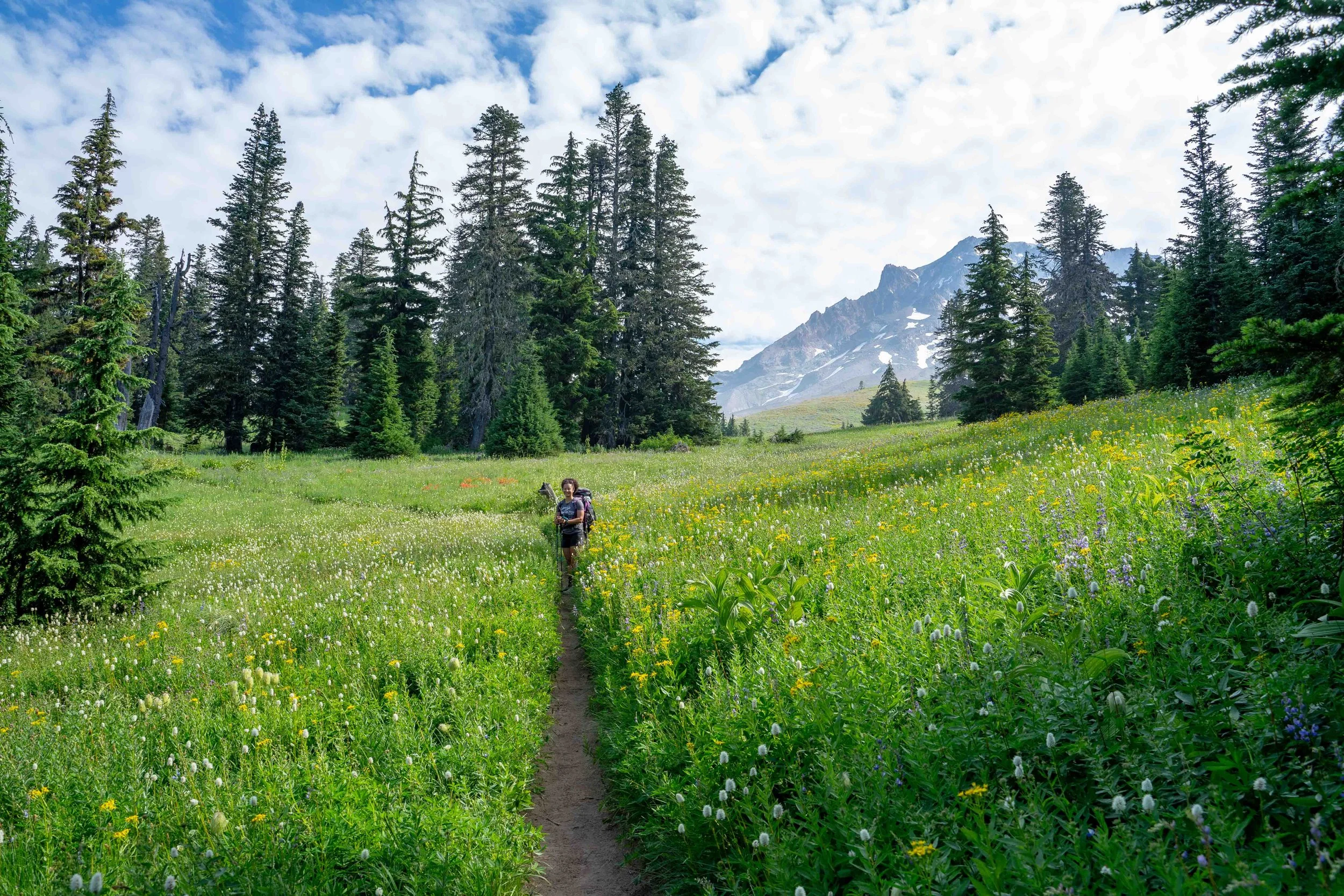
We reach the Zig Zag Canyon Rim at about 2.5 miles and take in the view of the mountain and the canyon below. It’s still smokey but it seems to be dissipating a little. The lupine and aster flowers here at the rim are lovely. We descend and cross the Zig Zag River and have our first real climb of the day. It is so lush and green and wildflowers are abundant.
After close to 4.5 miles, we reach the junction with the Paradise Park Trail. While the Paradise Park Trail is not apart of the Timberline Trail (…technically we didn’t complete the whole Timberline Trail!) it’s too beautiful to pass up. Paradise Park is a beautiful alpine area with meadows full of wildflowers. The forested trail climbs for a half a mile or so and opens up to a meadow. We take our time here. There are a lot of small butterflies flitting about (we’d see hundreds of them over the next three days!).


We continue hiking further into Paradise Park.


We encounter a family and the mom asks if we are backpacking “the loop” - I say yes! She says, “it’s 14 miles right?” we reply “oh we are actually backpacking the Timberline Trail, it’s about 41.5!” We all start laughing. (The Paradise Park Loop from the Paradise Park Trailhead is about 14 miles.)
After a little over 7 miles we rejoin the Timberline Trail/Pacific Crest Trail and continue the 3 mile, over 2,000 foot descent to the Sandy River. We encounter a number of backpackers climbing out of the canyon who look like they are ready for a break. We cross paths with a PCT hiker heading south on the trail and have a great chat about his trek (his favorite part of the PCT so far - he’s doing it in segments - has been the section north between Mt. Hood and the Columbia River!). Before we reach the Sandy River we filter water at Rushing Water Creek. This is when we first notice a few biting flies.
The Sandy River crossing is easy thanks to the tip from the PCT hiker - we walk about 300 feet upriver to where a bunch of logs form a makeshift bridge.
We have about a mile or so and about 400 feet of climbing before our lunch spot - Ramona Falls. I forget to take any photos of the waterfall - oops! At Ramona Falls we decide to hike the Ramona Falls Trail to where it joins the PCT at the Muddy Fork and take the PCT to the Top Spur Trailhead where it rejoins the Timberline Trail. I had read a number of All Trails trip reports of backpackers saying the blowdown area after the Yocum Ridge Trail junction was challenging to cross with packs on. (After talking to backpackers later in our trip, though, we realize it probably would have been doable and not too challenging.)
The Ramona Falls Trail follows Ramona Creek - it is so lovely in here. It’s shady and moss blankets the forest floor. Over 1.75 miles or so we lose about 700 feet of elevation (it dawns on us we will have to make up this loss on the climb to Top Spur!) We rejoin the PCT at the Muddy Fork and the 2 mile, 1,500 foot climb begins.
At Top Spur, we have the most clutch snack - a Snickers bar - of the day! We’ve covered about 16 miles and still have 3.5 miles or so and 1,500 feet of climbing to do. The climb along Bald Mountain Ridge is tedious (does it ever end?!) and the flies are relentlessly frustrating. This is a long stretch without access to a water source - from Ramona Creek to McGee Creek after the trail turns away from Bald Mountain Ridge. We encounter a bunch of day hikers returning from McNeil Point.
We hope to find a camp spot just past McGee Creek - near the McNeil Point Trail - about 3 miles from Top Spur. We filter water at the creek and continue climbing. When we reach the McNeil Point Trail we don’t find a suitable site (also there are no views of the mountain) so we continue to Cairn Basin where we know there should be ample sites. We cross Glisan Creek, climb a little more, and enter a wildflower filled meadow before entering Cairn Basin.
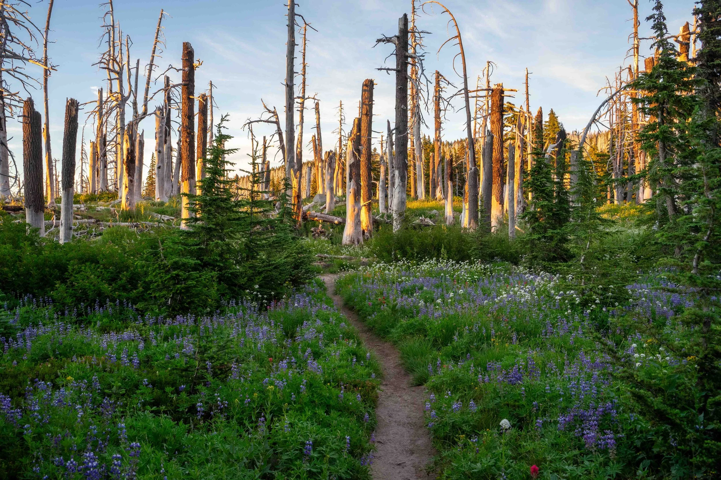
Parts of Cairn Basin burned in the 2011 Dollar Creek Fire - and evidence of the burn remains (and fireweed!) in this ghost forest. Lupine, red and orange Indian paintbrush, aster, and other species of wildflowers fill the meadows here. We find a flat site (not in the meadow) just beyond the Cairn Basin Shelter with a view of the mountain. My watch hits 20 miles for the day. We could not be happier to take our packs off!
The key to me not bonking at all today was the frequent snacking (rx bar, honey stinger waffle, gummies, dried mango, trail mix with chocolate, fruit bars), a high calorie lunch (bagel with lots of cheddar and avocado and salty potato chips) and electrolytes.


After dinner we hike back to Glisan Creek to clean off our very dusty legs and filter water. While Ladd Creek is closer to Cairn Basin, the water is too silty to filter. We’re not thrilled about adding .8 miles to the day but the section of trail is quite lovely especially with the sun starting to set and the changing light on the mountain.


As soon as we get back to our campsite, we get in the tent and call it a night.
Day 2: Cairn Basin to Newton Creek (14.8 miles, 3,563 feet of gain)
We have a slow start to the morning, enjoying a breakfast of coffee and oatmeal, before beginning our long walk to the east side around 9:15 am. We both are surprised that we don’t feel worse but it definitely takes a minute to get used to carrying our packs again.
We cross Ladd Creek after leaving Cairn Basin and reach Wy’east Basin, a small meadow area with a stream running through it, in about a mile.
After about 2.5 miles we reach Elk Cove Camp.

We reach the Coe Branch after about 3.5 miles. We have to hike/climb through a bunch of shrubs before getting to the crossing but thankfully the trail is obvious.
Over the next few miles there are a number of other creek crossings. We see a bunch of groups running the Timberline Trail counter clockwise. We cross Compass Creek and make our way towards the Eliot. This section of trail here is super dusty and generally not very fun. We switchback steeply down. Thankfully we see a number of ropes to guide us down to the Eliot crossing. It’s only slightly sketchy but I feel secure using the ropes to guide me down the steep section of rock and sand. We cross the Eliot and the slog to Cloup Cap Campground begins. After about 8.8 miles we reach the campground for lunch and to refill our water.
The next part of the day (about four miles to Gnarl Ridge with about 1,500 feet of climbing) is one of the most challenging of the entire loop for me. It’s a continuous climb from Cloud Cap to the Timberline High Point around 7,300. The trail initially after coming out of the trees is very sandy as we make our way up towards Cooper Spur.
It’s a slow few miles of climbing to the high point and it’s very exposed and rocky. Views of the impressive Eliot Glacier are excellent. We are relieved once we get to the high point knowing the rest of the day will be mostly downhill although we still have a lot of walking on Gnarl Ridge before re-entering the forest. I barely take any photos here although the views to the north are beautiful. We can see the Columbia River in the distance to the north east. We are again delighted to see a dozen or so small butterflies (they are everywhere! Even up here!).
We cross a number of snow fields on our descent from the high point (easy, except I do slip and fall once - I was fine). The view of the massive Newton Clark Canyon and the mountain from Gnarl Ridge is impressive and very different from just a few miles ago when we were around Cloud Cap. One of my favorite things about hiking the Timberline Trail is seeing the mountain from every angle - it changes so much depending on where you are.
We pass the remains of the Gnarl Ridge Shelter and our camp spot sheltered in the trees from the last time we backpacked the Timberline Trail in 2020. We have a few more miles to Newton Creek and it’s all downhill. It’s mentally challenging after the previous handful of miles. My feet and right knee hurt. The forest is lovely though. Another Snickers bar for the win!
After about 14.5 miles, we reach Newton Creek. This crossing is one of the most difficult of the loop, although we were able to cross on a number of branches without getting our feet wet. We find a campsite just on the other side as the trail re-enters the forest near a drinking water stream.
Day 3: Newton Creek to Timberline Lodge (7.86 miles, 2,277 feet of gain)
We wake early on Sunday knowing we have about 8 miles to cover before completing the trail back at the lodge. We then have to drive back to Portland, pull ourselves together, take an emotional lap, and pick up our kids from their grandparent’s house.
We’re packed up and start moving by 7 am. The trail climbs easily away from Newton Creek. I love hiking early in the morning before the sun is high and the light is harsh.


After about a mile, we begin the descent to Clark Creek. The view of the mountain here is possibly my favorite of the entire trip.


Shortly after we cross Clark Creek, we reach Heather Creek and Upper Heather Canyon Falls. Oh my, it is beautiful. The wildflowers! The butterflies! The waterfall! The lushness!


We briefly chat with a couple who are sitting in a campsite looking at the mountain enjoying their coffee. What a delightful way to start the day! Over the next few miles we meander through Mt. Hood Meadows. The flowers are beautiful.
At about 4.25 miles we start the over a mile descent to the White River. At this point I would much rather be walking uphill than down (almost all the time I’d rather be hiking uphill). The crossing at White River is not difficult although for the first time all weekend we get our feet wet. After we cross we begin the very sandy hike back up to the lodge. Although I remember this climb being longer and harder, I just keep putting one foot in front of the other. I’m daydreaming about lunch.
For this last photo, I use my remaining energy to squat down with my pack on to get the flowers in the frame. I’d say it was worth it although I do groan when I stand up and continue walking.
We arrive back to the lodge after hiking 42.72 miles with 10,847 feet of elevation gain - 52 hours after starting our clockwise lap around the mountain on the beloved Timberline Trail. I tell Lindsay I think this might be one of the athletic feats I am most proud of in my adult life. Our first backpacking trip together in four years and only my second since having twins. The last year and a half of cycling and strengthening helped prepare me for this. My body was ready. I’m so grateful for my health and fitness and the ability and privilege to walk with a heavy pack on for so many hours over just a few days with my favorite hiking and life partner.
(Now, I’m dreaming up a goal of hiking and jogging Portland’s Forest Park Wildwood Trail end-to-end to celebrate my 40th birthday in April. Hey, if I can walk 20 miles and 5,000 feet of gain with a pack on, I am hopeful I can prepare for 31.5 miles without a pack. Come join me!)
Timberline Trail, Mt. Hood, you are perfect. I’m forever astounded by the beauty of the Pacific Northwest. So grateful to call this place home.