In mid-July, my sister Kristin and I backpacked the High Lonesome Loop in the Indian Peaks Wilderness outside of Boulder, Colorado. My sister, a teacher, has spent a lot of her summers over the last decade plus backpacking. She’s completed a number of long trails (the Colorado Trail, the John Muir Trail, the West Highland Way in Scotland, the Dingle Way in southwest Ireland, and a number of sections of the Appalachian Trail). The last time we backpacked together was during the pandemic when we spent three nights in early August 2020 backpacking in the Eagle Cap Wilderness in northeastern Oregon’s Wallowa Mountains.
I knew it’d be special to go backpacking together, just the two of us. I was both excited and a little nervous (since it was my first backpacking trip in four years I wondered, was I fit enough? how would my body feel hiking at altitude?). Mostly, I was just excited to spend a few days outside and have a break from this beautifully wild season of life raising three young kids.
The Indian Peaks Wilderness in Colorado’s Front Range is divided into backcountry zones with quotas set for overnight camping. Kristin secured overnight permits for Jasper Lake Backcountry Zone and Middle Boulder BZ easily through recreation.gov.
On Sunday morning, we have lunch in Nederland before making our way to the very popular Hessie Trailhead, which is about 15 minutes from Nederland. On Fridays, Saturdays, and Sundays from May-October, free shuttle busses operated by Boulder Couty transport hikers to the trailhead from Nederland High School. When we reach the road closure on Eldora Road though, we are waved through to park at the trailhead as we had overnight permits for backpacking. (I believe we got lucky though - if the trailhead parking area had been full we probably would have been directed to take the shuttle.)
The High Lonesome Loop is about 16 miles but according to my Garmin watch we ended up backpacking a little more than 19 as we added on Betty Lake for our second night (and spent some time wandering Jasper Lake for a campsite). I highly recommend the side trip as Betty and Bob Lakes and the wildflowers up there are beautiful.
Day 1: Hessie Trailhead to Jasper Lake (6.62 miles, 2,201 feet of elevation gain)
We hike a half mile along Hessie Road before reaching Hessie Trailhead. After about 1.25 miles and 450 feet of elevation gain we reach a junction and head right following the Devil’s Thumb Bypass Trail. The views are lovely when we reach the Indian Peaks Wilderness boundary.

After about an hour of hiking we “run into” Kristin’s girlfriend Mary and their friend Gunnar who are running down from Jasper Lake! We chat for a few moments before continuing our climb towards the lake.
Around 3 miles we continue on the Devil’s Thumb Trail. After a little over 5 miles we reach Jasper Lake. We decide to continue on the Devil’s Thumb Trail down the lake to find a campsite (I believe there are seven campsites around the lake). We end up walking another 1.5 miles or so before we find a campsite and set up for the night. We get our mosquito nets out and make our way to the lake to filter water (there isn’t a stream nearby). Wildflowers, including Indian Paintbrush and Colorado Blue Columbine, line the lakeshore along the trail.


After dinner we wander back to the lake and enjoy the warm light on the mountains across the lake.
Since the mosquitos are so obnoxious we get in our tents early. I spend a few hours reading and sleep very poorly. I joke with Kristin in the morning that I felt like I didn’t actually fall asleep until 5:30 am since it was so restless and non-restorative. (We slept at about 10,900 feet - clearly my body didn’t like this.)
We have an easy start to the morning and enjoy a breakfast of oatmeal with dried fruit and coffee. By 9:45 am we are packed up and on our way. We climb gradually away from Jasper Lake and over the next mile I am just delighted by the scenery. Wildflowers line the trail.


The trail climbs a bit more steeply as we make our approach to Devil’s Thumb Lake.


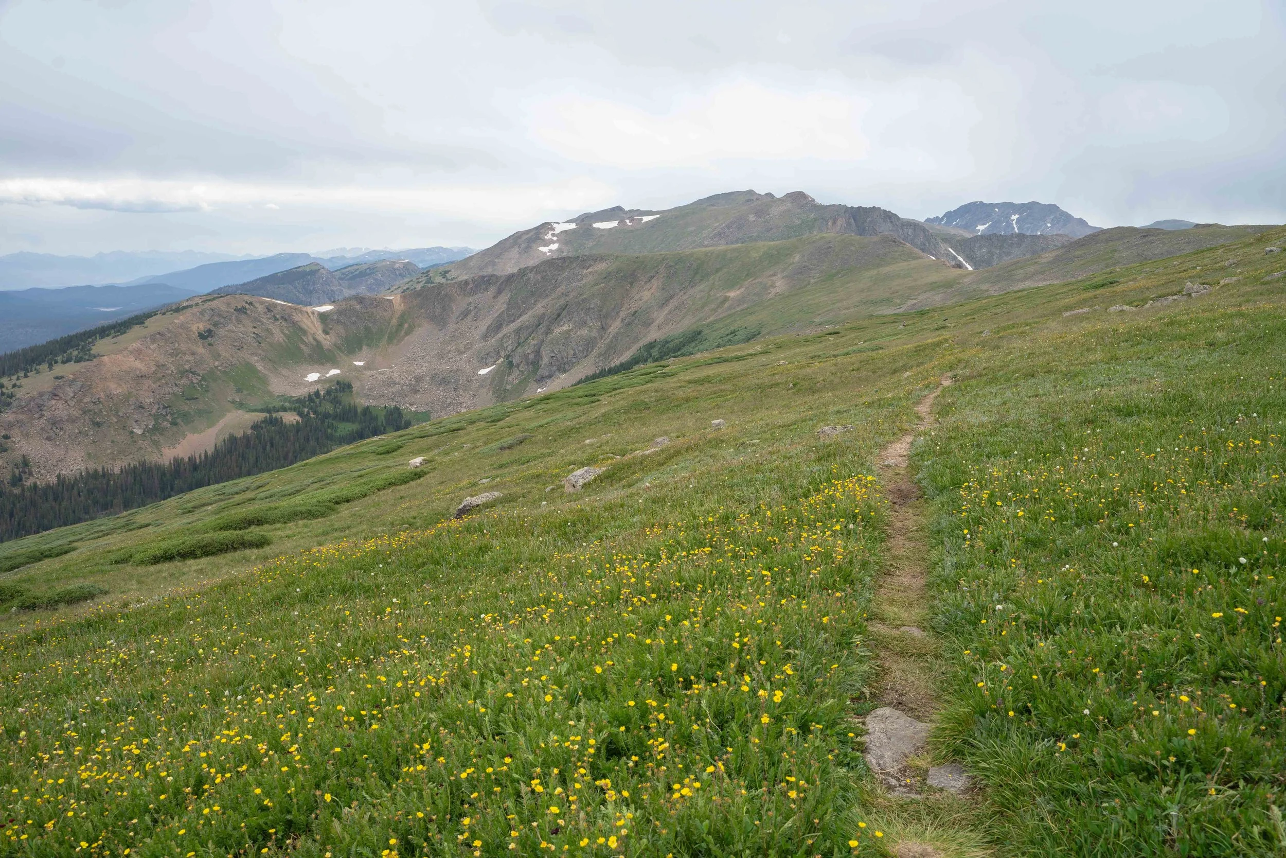
It’s about a mile from Devil’s Thumb Lake to the Continental Divide with about 800 feet of climbing. The views here looking back towards Devil’s Thumb and the small lake to the southwest of Devil’s Thumb Lake are some of my favorite of the whole loop.


When we reach the Continental Divide/High Lonesome Trail I’m glad to have a break from the strenuous climbing. To the west, we can see Winter Park and the surrounding mountains. This photo below shows the Divide looking north.
We briefly chat with two backpackers from Texas who were sitting enjoying a snack (the altitude and climbing seem to have tired them out). After two miles of walking along the divide we descend to our lunch spot above King Lake.


At King Lake, we decide to continue on the Bob and Betty Lakes Trail and find a campsite at Betty Lake. Just before the turn we see a moose and her two babies eating foliage near South Fork Middle Boulder Creek. I’ve never seen a moose in the wild so this is absolutely thrilling for me! Before I can switch to my 70-180mm lens, they disappear into the dense shrubs along the creek.
It’s about a half of a mile with a few hundred feet of elevation gain to Betty Lake. The views here are beautiful. Just after crossing a stream at Betty Lake we find a nice site away from the lake in the trees.
Shortly after we set up our tents and get in them for a quick rest it starts raining and continues for a few hours. We both enjoy a long rest. I doze and read my book and relish in having literally nothing to do other than enjoy being here in this beautiful place with my sister - even if it is raining.
The rain passes around 5 pm and we decide to have an early dinner. After dinner, we see the moose and her two calves approach Betty Lake and swim to the other side to eat the vegetation at the shore. I grab my camera and switch to my telephoto lens. Even though the moose are across the lake (about 125-150 yards away), I’m still a bit nervous.

Moose forage on the shore of Betty Lake across from our campsite.
As the moose swim back across the lake we decide that we need to create more distance between us so we walk back to our campsite. Once we are at our campsite, however, they look right at us and start walking toward us. I do not like this (!!!) so we walk up the Betty and Bob Lakes Trail well away from our campsite where we can see them from above. After a few minutes, it’s clear they’ve moved on. The moose never showed any signs of aggression but I am still glad we walked far away from them. After our nervous systems settle down, we decide to hike up to Bob Lake as the evening sun moves lower in the sky.
We walk along Betty Lake before turning back to the trail up to Bob Lake.


We are both so glad we hiked up to Bob Lake because the views at the lake and looking back to Betty Lake and down the valley towards Boulder are stunning.
Shortly after we return to our campsite we get in our tents as the mosquitos are still out for blood. Thankfully, I sleep much better tonight.
We set an alarm for 7 am and are on the trail by around 8:15 am. I’m looking forward to an easy, all downhill hike out to complete the loop. The most scenic part of our hike is the first 30 minutes or so as we hike on the Betty and Bob Lakes Trail back to the King Lake Trail.
Kristin, on our hike out from Betty Lake.
After about 4.25 miles of mostly forested trail we reach the junction with the Devil’s Thumb Trail which takes us back to Hessie Trailhead. After a little more than 6 miles, we’re back to the trailhead parking lot and 15 minutes from lunch in Nederland.
The High Lonesome Loop was wonderful, highlighted by incredible views of the Indian Peaks and along the Continental Divide, bountiful wildflowers of all colors, alpine and sub-alpine lakes, moose (!!), and of course one-on-one time with my triplet sister in the wilderness. What a gift it was to have a few days together - thanks Gram and Pops! - doing something we both love so much.